Location: 0.204S, 100.320E
Data period: Nov 15, 2002 --
Notes: The version number of the text and netCDF data is different,
but the contents of both the data are the same.
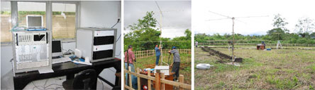
The original observation data of meteor trails and its radial velocity in the equatorial
mesosphere and lower thermosphere (70-110 km) taken by the meteor wind radar at Kototabang,
Indonesia (0.20S, 100.32E, 865m MSL). The data are stored in the text filenamed
mp(year)(month)(day).kototabang.mpd.
The lines 1-29 represent the file header which contains the site location
(latitude, longitude), height resolution, the number of range gate number and radar status
(operation frequency, antenna coordinate, record length and phase offset etc.).
The line 30 is each parameter name ('Date', 'Time', 'File', 'Rge', 'Ht', 'Vrad', 'delVr',
'Theta', 'Phi0', 'Ambig', 'Delphase', 'ant pair', 'IREX', 'amax', 'Tau', 'vmet', and 'snrdb')
while the lines 31 and below are date, time (universal time) and observation data.
For detailed information, please refer to the
metadata .
[NOTICE]: SINCE SEVERAL TEXT FILES IN THE PREVIOUS VERSION CONTAIN DATA GAPS
AND INCORRECT DATA, WE REPLACED THEM WITH CORRECT ONES. PLEASE DO NOT USE
THE WIND DATA DOWNLOADED FROM THIS HOMEPAGE BEFORE AUGUST 26, 2011
FOR ANY ANALYSES AND PUBLICATIONS.
The wind data are calculated from the original observation data with a weighting function.
They are stored in the text file named Wk(year)(month).(resolution).txt or
Wk(year)(month)(day).(resolution).txt.
The resolution abbreviations are h2t60min00, h2t60min30, h4t60min00 and h4t60min30.
For example, the h2t60 means weighted average with Gaussian factors over +/-2 km in height
and +/-60 minutes in time. The min00 shows that the center of the Gaussian window corresponds to
00 minute of every hour. The intervals of the wind data are every 2 km and 60 minutes.
If you want to know more information of this data, please refer to the
readme file (English, Japanese)
and access the
metadata .
[NOTICE (Feb 13, 2012)] We found that the long_name of "num", number of observed meteors
per hour, was incorrect in the older version (1.1.1 and earlier) of netCDF data.
The variable is not hourly rate but total number of meteors in a time and height bin
(e.g., +/-2 km and +/- 60 minutes for h2t60). The data itself is not wrong.
Please do not misunderstand the meaning of the number of meteors when you use this data
for any analyses and interpretations of meteor distribution.
The long_name was fixed in version 1.1.2.
The wind data are stored in the netCDF (network Common Data Form) file
named Wk(year)(month).(resolution).nc or Wk(year)(month)(day).(resolution).nc.
The resolution abbreviation and meaning are the same as the text data.
If you want to know more information of this data, please refer to the
readme file (English, Japanese)
and access the
metadata.
The time-height plot of horizontal wind data in the mesosphere and lower thermosphere
(70-110 km) estimated from the meteor wind radar at Kototabang, Indonesia
(0.20S, 100.32E, 865m MSL).
File names are composed of date and variable abbreviation: Wk(year)(month)(day).(resolution).gif
for daily plot, Wk(year)(month).(resolution).gif for monthly plot and Wk(year).(resolution).gif
for yearly plot.
If you want to know more information of this data, please refer to the
readme file (English, Japanese)
and access the
metadata.