Location: 6.361S, 106.658E
Data period: Oct 28, 1992 -- Aug 10, 1999
Notes: The version number of the text and netCDF data is different,
but the contents of both the data are the same.
- Serpong observatory (metadata)
- Serpong meteor wind radar (Instrument) (metadata)
Horizontal wind data estimated from the observation data (text format, version 1.0)
The wind data are calculated from the original observation data with a weighting function, and are stored in the text file named jkt(year)(month).(resolution).txt or jkt(year)(month)(day).(resolution).txt. The resolution abbreviations are h2t60min00 and h4t240min00. For example, the h2t60 means weighted average with Gaussian factors over +/-2 km in height and +/-60 minutes in time. The min00 shows that the center of the Gaussian window corresponds to 00 minute of every hour. The intervals of the wind data are every 2 km and 60 minutes.
If you want to know more information of this data, please refer to the
readme file (English, Japanese) and access the
metadata .
Horizontal wind data estimated from the observation data (netCDF format, version 1.0.2)
[NOTICE (Feb 13, 2012)]
We found that the long_name of "num", number of observed meteors per hour, was incorrect in the older version (1.0.1 and earlier) of netCDF data. The variable is not hourly rate but total number of meteors in a time and height bin (e.g., +/-2 km and +/- 60 minutes for h2t60). The data itself is not wrong. Please do not misunderstand the meaning of the number of meteors when you use this data for any analyses and interpretations of meteor distribution. The long_name was fixed in version 1.0.2.
The wind data are stored in the netCDF (network Common Data Form) file named jkt(year)(month).(resolution).nc or jkt(year)(month)(day).(resolution).nc. The resolution abbreviation and meaning are the same as the text data.
f you want to know more information of this data, please refer to the
readme file (English, Japanese)
and access the
metadata.
Time-height plots of wind (GIF format)
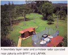
The time-height plot of horizontal wind data in the mesosphere and lower thermosphere (70-112 km) estimated from the meteor wind radar at Serpong, one of the south-west suburbs of Jakarta, Indonesia (6.36S, 106.65E, 50 m MSL). File names are composed of date and variable abbreviation: jkt(year)(month)(day).(resolution).gif for daily plot, jkt(year)(month).(resolution).gif for monthly plot and jkt(year).(resolution).gif for yearly plot.
If you want to know more information of this data, please refer to the
readme file (English, Japanese)
and access the
metadata.
| Year |
h2t60min00 |
h4t240min00 |
| 1992 |
1-day,
1-month |
1-day,
1-month |
| 1993 |
1-day,
1-month |
1-day,
1-month |
| 1994 |
1-day,
1-month |
1-day,
1-month |
| 1995 |
1-day,
1-month |
1-day,
1-month |
| 1996 |
1-day,
1-month |
1-day,
1-month |
| 1997 |
1-day,
1-month |
1-day,
1-month |
| 1998 |
1-day,
1-month |
1-day,
1-month |
| 1999 |
1-day,
1-month |
1-day,
1-month |
Created: 2013-12-13 11:26:45 +0900
RISH Metadata Management Group
Research Institute for Sustainable Humanosphere (RISH), Kyoto University
Gokasho, Uji, Kyoto 611-0011, Japan
E-mail: iugonet (at) rish.kyoto-u.ac.jp